Monday, September 27, 2010

Paddling along Woodhull Creek

Whenever we cross the small bridge on Woodhull Road (County Route 72) on our way to Bonnie's or C&R Hardware Store, we've always wondered what that creek was and whether we could take our canoe down there. Well, on one of our expedition beyond the Kayuta Lake dam, we found the way.

While leisurely paddling along the eastern shore of the Forestport Reservoir, we saw a narrow passage which we found out from a kind resident is Woodhull Creek.  And so onward we went.  Some parts of the creek were really shallow, but for the most part, it was an easy paddle, and oh, so quiet over there.


View Larger Map

After about a mile, we crossed under that steel bridge on Woodhull Road, beyond which the creek seemed to open up a bit.


Just beyond the turn though, it became rocky and shallow with some pretty fast flowing waters. After we docked the  boat, we saw this small rapids just a little way upstream.  Is this the last of the drops that make Woodhull Creek a popular whitewater destination?

Monday, September 20, 2010

Baker's Falls and Lansing Kill Falls

I have yearned to find these falls ever since I came across them on the Black River Canal Museum site. Supposedly located 2 miles south of Boonville, Baker's Falls is created by the waste weir of lock 64 of the Black River Canal.


And so on our most recent bike ride on the canal towpath, we were determined to make this discovery. As we rode along the trail, just above a deep gorge, the sound of rushing waters below heightened our excitement.  Finally, we reached this partially barricaded bridge, below which, the roaring waters diverged from the canal, cascading downwards to what is most likely to be the elusive falls.


Just beyond the other side of the bridge is a barely noticeable foot path.  Narrow, slippery and steep at some points, the path led down to one of the most magnificent sight near the towpath.


Baker's Falls is indeed an awesome thing to behold.  It's amazing to think that this water actually had come all the way from beyond Kayuta Lake, to Forestport , the feeder canal and down the Black River Canal.


Just opposite Baker's Falls is the Lansing Kill Falls.

Water from the Black River Canal join the Lansing Kill to form a partially underground stream, eventually reaching Pixley Falls.

Monday, September 13, 2010

A Bike Ride on the Black River Canal Towpath Trail - Part 2


This time, we drove south about 1.8 miles from where we ended our bike ride last time, to a parking spot alongside Route 46.  Judging from the overgrown weeds, not that many people enter the trail through this gate.


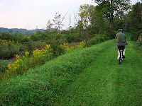
 Golden rods border the trail most of the way, interspersed by a variety of other wildflowers.  How much more beautiful it must be when all these flowers are at their peak.  The grassy trail appeared more manicured than most lawns this time of the year.


Below this partially barricaded bridge, the canal appears to have been dammed so that the water was now diverted downwards, forming the impressive Baker's Falls.  But more about that next time.

South of this point, the canal is mostly silted, overgrown with grasses and wildflowers.

Tuesday, September 7, 2010

A Bike Ride on the Black River Canal Towpath Trail

9/2/2010

From Boonville to Route 46...

After riding the Black River Canal Feeder Trail, it is but natural to continue onward to the Black River Canal Towpath which also is a cross-country ski trail maintained by BREIA. We have hiked parts of this trail before but today, we brought our bikes and started the ride from Boonville.

The Black River Canal has the record for the most number of locks per mile, 109 locks along its 35 mile course from Rome to Lyons Falls, NY.  The 25mile southern section from Rome to Boonville had 70 locks, rising 693 feet.  Riding this trail will not be a piece of cake.


Heading south from Boonville, the grassy trail was fairly flat for about a mile, until lock number 70.  It was quite uneven though because of the numerous tree roots crossing the trails.


We crossed Route 46 and passed a few locks on the way.  Water rushing down the locks make for small waterfalls, like this one just across the Domser Road trail turnoff.


The mainly downhill ride was fairly easy.  Once we reached the other Route 46 intersection, we made our way back.  As expected, the uphill ride back was more strenuous, making it more difficult to outrun the mosquitoes patiently waiting for us on the trail.