Monday, October 11, 2010

2010 Year in Review

Each summer at Kayuta keeps getting better and better. Being able to spend more time here allowed for more entertaining and discovery.

Paddling around the lake continued to be a favorite activity, with Woodhull Creek being added to our list of paddling routes.


We've hiked new places like the Bald Mountain Fire Tower, Moss Lake, the Alder Creek Gorge Trail.

We rode our bikes on trails we've only hiked before - the Black River Canal Feeder Trail and parts of the Black River Canal towpath, even discovering some fabulous waterfalls along the way.


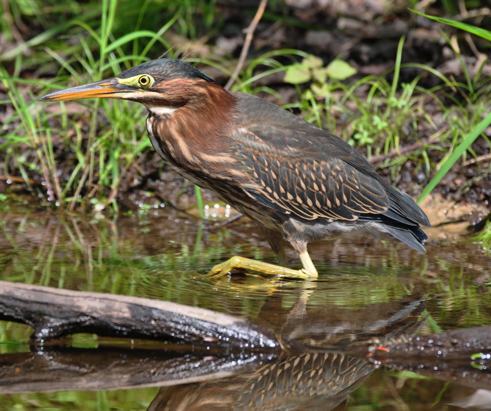
And we have never seen so many different wildlife around the lake - a woodpecker, hummingbirds, blue heron, green heron and even a snake as well as the usual ducks, deer, turkeys and turtles. I even saw the loon three times.


But now, the camp is closed for the season and we'll just have to savor these memories until next year's opening day.

Monday, October 4, 2010

Alder Creek Gorge Trails

One fine afternoon in mid-September, we decided to go for a short hike on one of the Egypt Road trails. A cross-country ski trail owned and maintained by BREIA, it is open for hiking and biking in the summer. We have done one of the hikes here before but this time, we went to the second parking lot which is about 1 3/4 mile on the right after making the turn from Route 12 in Alder Creek.

From the parking lot, we had to cross Egypt Road to take the Alder Creek Gorge trails (blue trail on the map).


The warming hut that provides shelter to cross-country skiers in the winter was closed for the season.


Following the sign , we quickly walked up the trail through a deciduous forest.  True to its name, the Rim Trail runs at the lip of the gorge which  unfortunately, we could not see because of the dense foliage.  Not until we reached a clearing aptly named the Adirondack Overlook were we able to see some view. With the valley below and the high peaks in the distant horizon, this would have been a fantastic scenery were it not  marred by the presence of the electrical lines right smack in the middle of the view.


From there, we followed the Moss Trail and doubled back to the Rim Trail.  With some more daylight remaining, we had time to read some of the markers along the trail describing the nearby vegetation as this patch of allegheny blackberries.
We were even able to go done one of the gullies (Gully II), a black diamond cross-country ski trail leading to the Creek View Trail. The climb back up to the Rim Trail was quite an aerobic workout.

This will certainly not be the last time we'll visit these trails.

Friday, October 1, 2010

Turtles Galore

After getting used to seeing turtles on Culver Brook, I thought I'll never get excited about seeing turtles again. Until my husband and I took that canoe ride beyond the Kayuta Lake Dam.

Just before or at the beginning of the Forestport Reservoir, we could see a bunch of tree stumps on the west side of the water.  A majority of the stumps was occupied by sun-bathing painted turtles.  Overall, we must have seen at least 30 of the creatures.


Monday, September 27, 2010

Paddling along Woodhull Creek

Whenever we cross the small bridge on Woodhull Road (County Route 72) on our way to Bonnie's or C&R Hardware Store, we've always wondered what that creek was and whether we could take our canoe down there. Well, on one of our expedition beyond the Kayuta Lake dam, we found the way.

While leisurely paddling along the eastern shore of the Forestport Reservoir, we saw a narrow passage which we found out from a kind resident is Woodhull Creek.  And so onward we went.  Some parts of the creek were really shallow, but for the most part, it was an easy paddle, and oh, so quiet over there.


View Larger Map

After about a mile, we crossed under that steel bridge on Woodhull Road, beyond which the creek seemed to open up a bit.


Just beyond the turn though, it became rocky and shallow with some pretty fast flowing waters. After we docked the  boat, we saw this small rapids just a little way upstream.  Is this the last of the drops that make Woodhull Creek a popular whitewater destination?

Monday, September 20, 2010

Baker's Falls and Lansing Kill Falls

I have yearned to find these falls ever since I came across them on the Black River Canal Museum site. Supposedly located 2 miles south of Boonville, Baker's Falls is created by the waste weir of lock 64 of the Black River Canal.


And so on our most recent bike ride on the canal towpath, we were determined to make this discovery. As we rode along the trail, just above a deep gorge, the sound of rushing waters below heightened our excitement.  Finally, we reached this partially barricaded bridge, below which, the roaring waters diverged from the canal, cascading downwards to what is most likely to be the elusive falls.


Just beyond the other side of the bridge is a barely noticeable foot path.  Narrow, slippery and steep at some points, the path led down to one of the most magnificent sight near the towpath.


Baker's Falls is indeed an awesome thing to behold.  It's amazing to think that this water actually had come all the way from beyond Kayuta Lake, to Forestport , the feeder canal and down the Black River Canal.


Just opposite Baker's Falls is the Lansing Kill Falls.

Water from the Black River Canal join the Lansing Kill to form a partially underground stream, eventually reaching Pixley Falls.

Monday, September 13, 2010

A Bike Ride on the Black River Canal Towpath Trail - Part 2


This time, we drove south about 1.8 miles from where we ended our bike ride last time, to a parking spot alongside Route 46.  Judging from the overgrown weeds, not that many people enter the trail through this gate.


 Golden rods border the trail most of the way, interspersed by a variety of other wildflowers.  How much more beautiful it must be when all these flowers are at their peak.  The grassy trail appeared more manicured than most lawns this time of the year.


Below this partially barricaded bridge, the canal appears to have been dammed so that the water was now diverted downwards, forming the impressive Baker's Falls.  But more about that next time.

South of this point, the canal is mostly silted, overgrown with grasses and wildflowers.

Tuesday, September 7, 2010

A Bike Ride on the Black River Canal Towpath Trail

9/2/2010

From Boonville to Route 46...

After riding the Black River Canal Feeder Trail, it is but natural to continue onward to the Black River Canal Towpath which also is a cross-country ski trail maintained by BREIA. We have hiked parts of this trail before but today, we brought our bikes and started the ride from Boonville.

The Black River Canal has the record for the most number of locks per mile, 109 locks along its 35 mile course from Rome to Lyons Falls, NY.  The 25mile southern section from Rome to Boonville had 70 locks, rising 693 feet.  Riding this trail will not be a piece of cake.


Heading south from Boonville, the grassy trail was fairly flat for about a mile, until lock number 70.  It was quite uneven though because of the numerous tree roots crossing the trails.


We crossed Route 46 and passed a few locks on the way.  Water rushing down the locks make for small waterfalls, like this one just across the Domser Road trail turnoff.


The mainly downhill ride was fairly easy.  Once we reached the other Route 46 intersection, we made our way back.  As expected, the uphill ride back was more strenuous, making it more difficult to outrun the mosquitoes patiently waiting for us on the trail.

Monday, August 30, 2010

A Green Heron on Kayuta Lake

What a treat it was to see this green heron while canoeing on Kayuta Lake.  This small, stocky wading bird is commonly seen in swamps and marshes, along creeks and streams, lake edges and pastures.  It did not seem perturbed by our presence as it nonchalantly went about foraging for its food.

Monday, August 23, 2010

We have hummingbirds, finally

After last year's unsuccessful attempt to attract hummingbirds, we decided to change tactics.

First, we got a new feeder which we hang away from the first one.  Lo and behold, the following day, we had hummingbirds.

Next, we moved our original hummingbird feeder, a pretty glass one, next to the new feeder.  And indeed, after a day, a hummingbird was seen feeding from it.  But the next day, we saw the hummingbird spitting out the sugar solution and never came back to use the glass feeder.  For some reason, the solution must have gotten rancid which supposedly can happen more quickly with glass feeders which get hotter under the sun than a plastic one.


So, we just moved the plastic feeder to the original spot where we can easily view the hummingbirds whenever they come.  And what a joy they have been since then.


Monday, August 16, 2010

Moss Lake

July 25, 2010

After our hike to the Bald Mountain Fire Tower, we headed for the town of Inlet where we had our picnic lunch overlooking the public beach on Arrowhead Park. It was a little chilly by the water but we still could not forego of the mandatory homemade gelato treat from Northern Lights Ice Cream, negating all the caloric expenditure from the earlier hike.

Back on Route 28, we turned on Big Moose Road by Eagle Bay hoping to explore the area of Big Moose Lake. Unable to find a good vantage point to the lake, we turned around and were drawn to the trailhead for Moss Lake where some people were unloading their kayaks from their cars.

An easy 0.1 mile walk gave us a good view of this serene lake. We quickly lost site of the couple carrying their kayaks just ahead of us. The easy portage is likely one of the reasons this is a popular destination for canoers and kayakers.


We decided to do the 2.5 mile loop around the 115 acre lake. Not only hikers and bikers are allowed here but horses as well, so we had to watch out for the occasional droppings. This path, originally built in 1924, was after all, the bridle path of the Moss Lake Camp for Girls which operated between 1923-1972.

Later, the camp was briefly occupied by the Ganienkeh people, of the Mohawk nation (1974-1978). Ever since the remaining buildings were razed in 1979,  no new development has been built around the lake and is now a recreation site managed by the NY State DEC. There are 8 campsites scattered around the lake. Permits are only required if camping for more than 3 days and for groups of more than 10.


We checked out one of the 8 campsites, each apparently with its own privy.  This one has its own trail to the lake but is not one of the 3 sites with direct boat access. 

The trail mostly goes through the forest and only touches the lake at the southwest corner. We saw our kayakers here which they claimed is their favorite swimming spot.

Near this spot, one can turn towards Bibb Lake and Sis Lake which for us would have to wait another time.  The trail remained relatively flat and easy and we quickly made it back to our starting point.  We missed the
observation deck where nesting ospreys and loons are frequently spotted.

Moss Lake will certainly will be in our list of future kayak destinations.

Wednesday, August 11, 2010

A Snake Encounter on Kayuta Lake

Poisonous snakes are present in New York state. Although there are many biting snakes, only 3 of the 16 native species carry venom that pose a danger to human life. We nevertheless were a little wary when we saw this little creature slithering about our deck.


Is it poisonous? Supposedly, poisonous snakes have vertical pupils which this did not have. Actually, it was only a common garter snake (Thamnophis sirtalis). Characteristically docile, its bite could nonetheless cause swelling and rash in humans, a reason to stay clear of its way.


Ref: Snakes of New York State

Monday, August 9, 2010

Bald Mountain Fire Tower

July 25, 2010


Bald Mountain, also known as Rondaxe Mountain has one of the most popular Adirondack fire towers. The first tower, a wooden one, was erected in the summit in 1912 and replaced with the present steel tower in 1917. The tower closed in 1990 and reopened on June 18, 2005.

From Kayuta Lake, we drove on Rt 28 up to Old Forge. About 4.5 miles past the Tourist Information Center, we turned left at Rondaxe Road,  clearly marked with a NYS DEC sign.  The trailhead is about 0.2 mile farther on the left side. We arrived there close to noon on a Sunday and the parking lot was packed.

The trail (about 1 mile long) is fairly level at the start and then rapidly ascends, a large part of which is through bedrock.  Exposed roots of tall spruces and firs clinging to the rock make the trail quite interesting. Fine views of 2nd, 3rd and 4th Lakes can be seen along the way but the panoramic view from the razor-edged cliff at the 2350 ft summit is a lot more spectacular.


Click the picture above and below to see the full panorama.


We climbed up the tower where we got a 360 degree view of the area.

   Composite of views from 3 sides of the tower

Inspired by views like these, people have joined the Fire Tower Challenge sponsored by the Glens Falls-Saratoga Chapter of the Adirondack Mountain Club (ADK). The towers are described in Views from on High: Fire Tower Trails in the Adirondacks and Catskills. Click here for the application. One does not have to be a member of the ADK to register.

Monday, August 2, 2010

A Bike Ride on the Black River Feeder Canal Trail - Part 3

 Boonville to Hawkensville Road
July 22, 2010


This time, we headed to Boonville, the end of the feeder trail.


At Erwin Park, a covered bridge crosses the canal close to the start of the trail.


The trail surface here appeared more even, making it easier to ride compared to  the 2 previous segments.  It's a popular walking and jogging path for residents nearby.

Although there were still some forested sections, plentiful wildflowers, birds, and butterflies (one of which seemed to follow me through the whole course), it was even less remote than the segment  from Edmonds Rd to Hawkensville. Some roads were visible beside the trail and there were no meadows to behold. The  trail was broken by several roads which we had to cross. 


It was a treat to see these kayakers who gave us a demonstration on how to cross under this low bridge on Sargent Road.


During our previous rides from Forestport and Edmonds Road, the feeder canal had been closely following the route of the Black River.  At about the Moose River Road crossover, the canal diverged from the river, going southward to Boonville while the Black River continued northward to Lake Ontario. This information I gathered looking at Mapquest's aerial map.


Three miles later, we reached our goal - the completion of the feeder canal bike trail.  It took us 3 days to ride the whole trail but hey, this was my first foray (not my husband's) into distance biking.

Next time, I hope to make this in one trip.