Monday, August 17, 2015

Watkins Glen State Park

South of Seneca Lake is the most famous state park in the Finger Lakes, Watkins Glens, which USA Today's Readers' Choice Poll voted the 3rd best state park in the US.  This is quite impressive since according to the National Association of State Park Directors, there are more than 2,200 parks and more than 6,200 additional recreation and educational areas administered by the various states in the nation.  Another NY state park, Letchworth Park, which we had visited a few years ago garnered the top honor.

Watkins Glens is about 150miles from Kayuta, which would have been quite a drive for us were we not already on Cayuga Lake doing the Wine Tour and seeing the sites (Montezuma National Wildlife Refuge, Taughannock Falls).

After spending the night in Ithaca, we drove west towards the village of Watkins Glen and paid $8 to park close to the main entrance to the park.


On the left of the main entrance water can be seen coming from a hole in the cliff below the stone bridge.  This comes from a short tunnel that millers had chiseled through the rocks in the 1800's.  Water from Glen Creek then poured into a "flume" trough that led to a flour and feed mill that was located at what is now the parking lot.


Main Entrance

We went through the main entrance that had been carved through the limestone rock towering 200 feet high.  This lead to a set of stairs through the tunnel ending in the Sentry Bridge, the stone bridge we had seen from below.


Glen Creek can be seen twisting at the bottom of the gorge 21 feet below.  Twelve thousand years ago, the gorge did not exist but was solid rock beneath the creek flowing down the west side of glacier carved Seneca Lake. Thousands of floods through the years eroded layers of limestone and shale creating the gorge, the creek flowing down in a series of 19 waterfalls that descend like the steps of a staircase.


We followed the 1.5 mile long Gorge Trail through stone steps and staircase that hug the cliffs,through tunnels and bridges following the course of the creek, which would ascend nearly 500 feet with more than 800 steps. Before the late 1930's these stonework walkway and stairs did not exist. When the park first opened to the public in 1863, visitors used ladders, wooden stairs and walkways.  Once it became a state park in 1906, tunnels, concrete bridges and staircases with iron railings were built, many of which, however did not survive the great flood of July 7, 1935.

Minehaha Falls


Minehaha Falls plunges 21 feet down to a heart-shaped pool.


Cavern Cascade


The trail runs behind Cavern Cascade as it pours over a sandstone ledge spraying visitors with its cooling mist before dropping 50 feet below. 


Central Cascade

At a viewing area about midway along Glen Cathedral, a long area flanked by 200ft cliffs on both sides, this pool of water is aptly termed baptismal font with the 60ft tall Central Cascade  up ahead. Visitors on the Gorge Trail go through the tunnel seen on the upper right then up more stairs ending at Folly Bridge above Central Cascade.


Rainbow Falls
After Folly Bridge and the Glen of Pools with its many sculptured pools and potholes is Rainbow Falls which comes from a tributary of Glen Creek which it joins after plunging 95 feet.   It is the second named falls in the park where the trail goes behind the falls.  We did not get to see the rainbow that is frequently seen here.


Rainbow Falls and Triple Cascade


Just up ahead, the creek drops 12, 8 and 6 feet in a Triple Cascade as it receives waters from Rainbow Falls.


Pluto Falls


Nine foot high Pluto Falls,  its name inspired by the Greek god of the underworld, is in an extremely narrow gorge with overhanging cliffs enveloping it in a perpetual shadow.


 We passed the junction between Gorge Trail, Indian Trail and the Finger Lakes Trail at the Mile Point Bridge and continued the next half mile along the wide and level path, the stream being calm at this point.

The New York Central Railroad Bridge, first built in 1877, destroyed by floods in 1935 and only recently  rebuilt, can be seen in the distance.


At the end of the path is Jacob's Ladder, a really steep (nearly 200 steps) staircase leading to the upper entrance area where there is a snack bar/souvenir shop, parking lot.  The bathrooms were closed but at least the porta potties had water for washing your hands.


From here, one can go back to the main entrance via a shuttle or take Indian Trail which follows the north rim and can connect with the Gorge Trail at different points.


View of gorge from Lover's Lane
After a small snack, we decided to trace our steps back to Gorge Trail to take another look at the gorgeous falls,  taking a little side trail to Lover's Lane.


Suspension Bridge

r
View of Gorge Trail and creek fom suspension bridge.


We then crossed the suspension bridge and walked to the lily pond around which used to stand the Glen Mountain House, a Victorian Inn that opened in 1872 but burned down in 1903.


Lily Pad


 From here, one could go to the South Entrance, continue the hike on the South Rim Trail (Finger Lakes Trail) or head for one of the campgrounds in the park.  For us, we headed back to Gorge Trail, once more passing behind Cavern Cascade then towards the exit.


The  2 1/2 hours we spent to go slightly over 3 miles on a nearly complete round trip on Gorge Trail plus a little side trip was well worth the time.  We did not even notice the effort. The views were indeed awesome and something we would love to see again.  Maybe next time, we can identify more of the other 19 falls in the glen.  And maybe hike the other trails too.


References:
1) NY Falls. Watkins Glen State Park.
2) Watkins Glen State Park. Waterfalls in The Western Half Of New York State
3) Waterfalls of the Northeastern United States
4) Walk in the Park. Exploring parks in the Finger Lakes of New York and beyond.
5) Watkins Glen State Park.New York State of Opportunity. Parks, Recreation and Historic Preservation.
6) 10Best Readers' Choice Awards. Best State Parks
7) America's State Parks


Monday, August 10, 2015

Taughannock Falls State Park

After ending our brief tour of the Cayuga Lake Wine Trail, we just had to stop at one of the outstanding attractions in the Finger Lakes and the whole northeast.  Driving south on NYS Rt 89, we turned onto the Taughannock Park Road in Trumansburg to the falls overlook.  The falls can already be seen from the end of the parking lot with only a few short steps down to the nice viewing area.

The name Taughannock could have originated from the Algonquian word Taconic ("in the trees"), from the Delaware word Taghkanic ("great fall in the woods) or after a Lenape (Delaware) chieftain killed in a nearby battle named Taughannock.


Plunging 215 feet to a deep pool surrounded by rocky cliffs towering nearly 400 feet above, Taughannock Falls is the tallest free falling waterfall in the northeast, higher than any of the three falls comprising Niagara Falls (American Falls -180ft, Canadian Falls - 170 ft, Bridal Veil Falls -181 ft). It has, however, much lower volume, its moderate flow sometimes becoming a trickle in the summer. Following the heavy rains prior to our visit, the flow of water from the falls was tremendous enough.


To get a closer view of the falls from below, we drove a little further south on NYS Rt 89 to the Taughannock State Park. We took the Gorge Trail, a 3/4 mile trail that follows the Taughannock Creek to the base of the falls. 


Taughannock Trail Map


We passed Lower Falls,  a 15 ft high cascade which is easily seen from the parking lot.  The third waterfall in the park , 100ft high Upper Falls can be seen in the narrow upper gorge,  requiring a hike on the north or south rim trail, something we were not prepared to do at the time.

The trail was flat and wide, flanked by high cliffs or dense growth of maples and birches on one side and the creek on the other.  It was hot and humid that afternoon but the walk was relatively pleasant.  Still, it was tempting to join the people walking alongside the creek, some even going for a dip to cool off.


At the small bridge crossing the creek, we immediately saw the majestic waterfall and were rewarded  by its refreshing mist at the end of the trail.


The walk back to the car was anti-climatic until we decided to see the lakeside part of the park.  In the waning hours of the day, the lake seemed so peaceful, with only a few folks on kayaks and SUPs, families fishing off the shore and hardly any power boats, a proper ending to our day on Cayuga Lake.


References:
1. Taughannock Falls State Park. New York State. Parks, Recreation and Historic Preservation.
2. Taughannock Falls State Park. Paleontological Research Institute.
3. Taughannock Falls State Park. NYFalls.com
4.Taughannock Falls State Park.VisitIthaca.com
5. Taughannock Falls. Taughannock.com
6. Hiking Trails at Taughannock Falls. CNY Hiking.


Saturday, August 30, 2014

Remsen Falls in Remsen

Aside from the "not really a waterfall" Remsen Falls, there is another falls of the same name in the town of (where else?) Remsen. This one can even be found in the list of Northern New York Waterfalls.


Going on Route 12 to the village of Remsen, we turned onto Steuben Street, left on Main Street and then right on Prospect Street.  We took the first right turn and parked right after the railroad tracks before the closed bridge, the Cincinnati Creek briskly flowing below it.


On foot, we followed the tracks southward,  parallel to the creek, the rambling of the waters progressively increasing in intensity.

After about a hundred yards, the falls came into view.


Wider than its 20 foot drop, this is said to be a curtain cascade type of waterfall.  Although it can be seen from Prospect Street, one has to get close to it to appreciate its beauty. Feeling the cold mist from the falls is surely worth the extra steps.


Saturday, August 23, 2014

Remsen Falls


By all accounts, Remsen Falls is not really a waterfall but just some rapids along the south branch of the Moose River in the Black River Forest of the Adirondack Park. It is supposedly a scenic place for a picnic or go camping. And so after our hike to Bear Lake, we decided to take our lunch to the "falls".

 The trailhead to Remsen Falls is also on Wolf Lake Landing Road, about 3.2 miles from the McKeever Trailhead parking area, 2.1 miles from the Bear Lake trailhead.  We parked at the small parking area just before the barrier. The road is handicap accessible although motor vehicle access is only allowed to permit holders who can obtain the combination to the lock on the gate by calling the Herkimer DEC office at 315-866-6330.


We walked in the middle of the road since tire tracks had created muddy trenches on both sides.


At 0.2 mile, we reached a four way junction- to Woodhull Mountain, to the McKeever Parking area and all the way to the Bear Creek Parking area.  We continued on the trail to Remsen Falls.
.
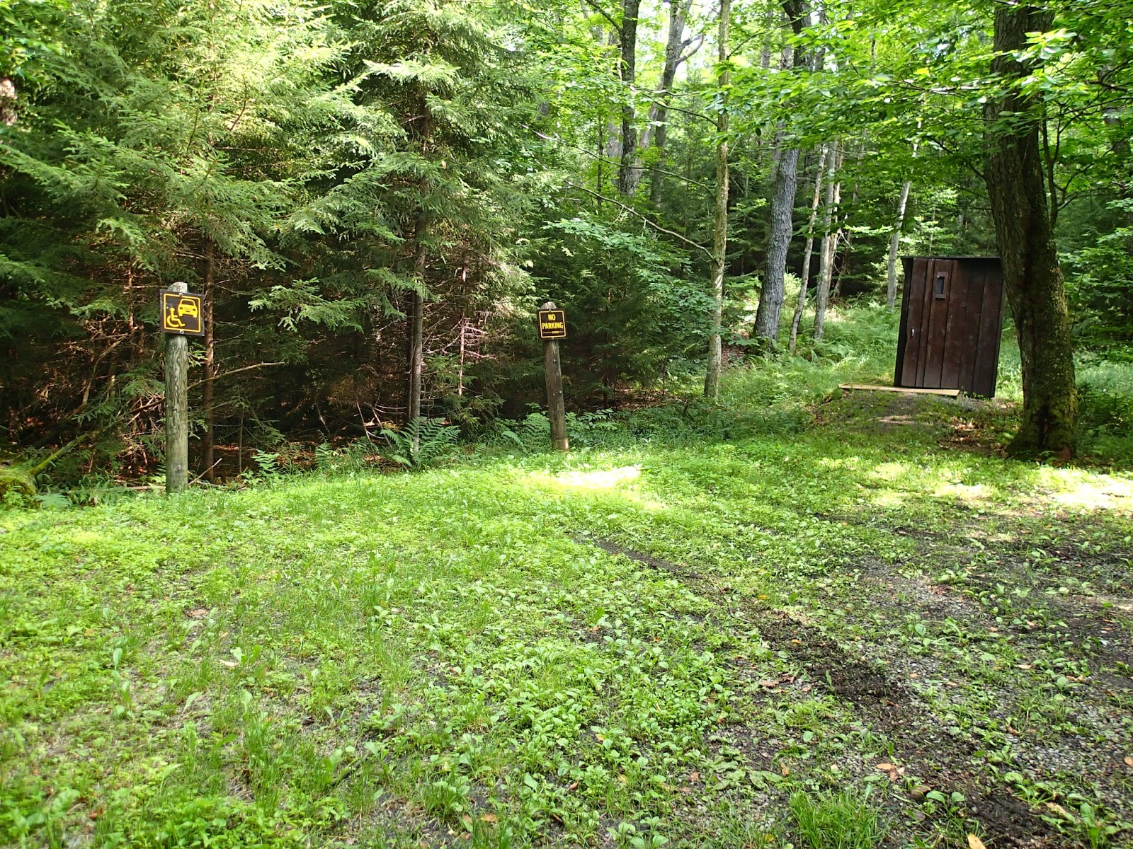
 At 0.5mile, we reached a small parking area for the disabled with a privy at one end of the lot. The trail then became narrower but no longer muddy.  A wheelchair can easily navigate this trail.


Shortly, we reached a clearing with a picnic table and a nice view of the Moose River.  The Remsen Falls lean to can be seen at a the distance across the water.


After a short lunch at this site, we followed the path to the left of the picnic table.  It crossed 2 small streams.


-

 Then there was an unofficial campsite with this old picnic table.  Just off to the side, we were able to get close to the water for a good view of Remsen Falls.


Remsen Falls


Immediately across, we can see the Remsen Falls lean to.  This can be hiked to from Nick's Lake Loop.

It was indeed a peaceful and scenic place which we had to ourselves the whole time. We could have stayed here longer were it not for the pesky bugs that drove us back to our car on Wolf Lake Landing Road.   

Tuesday, August 13, 2013

Crandall Falls


Crandall Falls is located along the Black River in the town of Forestport. Our previous attempt to find the falls was unsuccessful because of lack of reliable directions.  This time, thanks to the detailed description by Northern New York Waterfalls, we had no problem finding it.


Driving along Muthig Road which becomes Roberts Road, we crossed a smal metal bridge with the NYS DEC indicating the Little Black Creek Fishing Access Site.


About 1/4 mile down the road, a sign directed us towards the Black River Public Fishing Stream.  The sign on the post said Jeep Trail Road Private Drive which apparently was an unofficial sign since all the maps we've consulted stated that this was supposed to be Crandall Falls Road. No wonder we missed it the first time around.


We parked our car at a parking spot about 1.2 miles down the narrow jeep trail.  The road was getting even narrower and muddy but we could have driven another 0.2 mile to the other parking lot close to the trail.  We followed the trail on the right side of the parking lot which went down and took us alongside the river to the designated fishing spot.


Although there were DEC markers on a trail that went uphill and to the left, we followed the narrower trail on the right which ran alongside the river.  We assumed that the "Private Property No Trespassing" signs on the left side of the trail did not include the trail itself.  About 200 feet downstream, we saw the waterfall.


It was not a big waterfall.  Although it might not even meet the 15ft vertical drop qualifying criteria to be included in the World Waterfall Database which claimed to be the "webs most authoritive source about waterfalls", it is there because of it's history of recognition.  After all, it is one of only two waterfalls in Oneida county that are registered with the GNIS (Geographic Names Information System) of the US Geological Survey.  The other one is Pixley Falls.


It was a beautiful day for a hike, breezy with low humidity, so we continued to follow the trail.  Another way to get to the falls is to paddle upstream (for about 2 hours) or take some powerboat from the mouth of Kayuta Lake.  As the river turns rocky at some point, anybody going this way would still have to anchor/beach the boat and hike up to the falls.  We had hoped to be able to follow the river downstream to this point. Alas, the trail ended at the edge of a small tributary and unless we cross the river, we could not continue.  Maybe another time, we'll be prepared to wade across (and even take a swim) or find another trail to take us there.